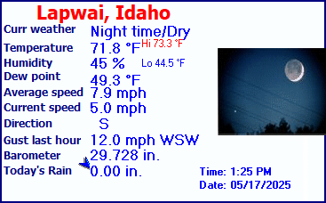
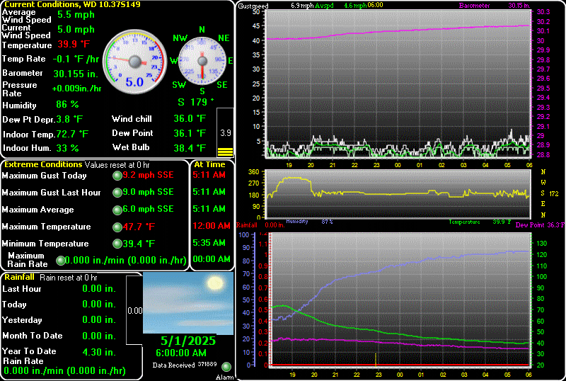
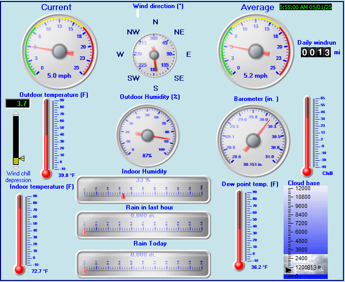
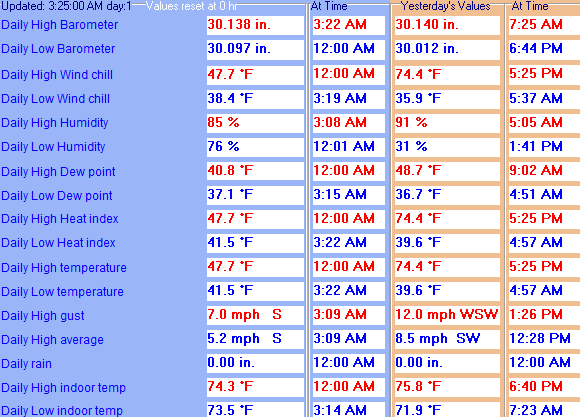
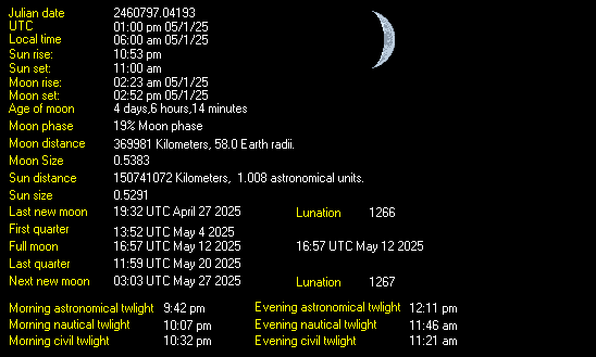
| Weather Data | |||
|---|---|---|---|
| LAST READING AT TIME: 11:45 PM DATE: April 25 2024, time of next update: 11:50 pm | |||
| Current Weather | Dry | Current Temperature | 50.8°F (10.4°C), Apparent temp 50.6°F |
| Maximum Temperature (since midnight) | 72.0°F at: 2:59 PM | Minimum Temperature (since midnight) | 37.3°F at: 5:25 AM |
| Average windspeed (ten minute) | 0.2 mph | Wind Direction (ten minute) | SE (135°) |
| Windchill Temperature | 50.8°F | Maximum Gust (last hour) | 3.0 mph at: 10:51 PM |
| Maximum Gust (since midnight) | 26.5 mph at: 6:25 PM | Maximum 1 minute average (since midnight) | 16.9 mph at: 6:26 PM |
| Rainfall (last hour) | 0.00 in. (0.0 mm) | Rainfall (since midnight) | 0.08 in. (2.0 mm) at 10:27 PM |
| Rainfall This month | 0.97 in. (24.6 mm) | Rainfall To date this year | 3.90 in. (99.1 mm) |
| Maximum rain per minute (last hour) | 0.00 in/min | Maximum rain per hour (last 6 hours) | 0.04 in/hour |
| Yesterdays rainfall | 0.00 in | DewPoint | 48.6°F (Wet Bulb :49.7°F ) |
| Humidity | 92 %, Humidex 52.5°F | Barometer corrected to msl | 29.791 in. (1008.8 hPa) |
| Pressure change | -0.01 in. (last hour) | Trend (last hour) | STEADY |
| Pressure change (last 12 hours) | -0.03 in | Pressure change (last 6 hours) | +0.06 in |
Expires:202404261100;;383722
FPUS56 KOTX 260403
ZFPOTX

Zone Forecast Product for Eastern Washington and North Idaho
National Weather Service Spokane WA
902 PM PDT Thu Apr 25 2024


IDZ026-WAZ032-261100-
Lewiston Area-Lower Garfield and Asotin Counties-
Including the cities of Lewiston, Lapwai, Peck, Culdesac,
Gifford, Clarkston, and Pomeroy
902 PM PDT Thu Apr 25 2024

.REST OF TONIGHT...Rain showers in the evening, then a chance of
rain showers overnight. Lows in the 40s. West wind 5 to 15 mph
with gusts up to 20 mph in the evening, becoming light and
variable. Chance of precipitation near 100 percent. Rainfall
amounts less than a quarter of an inch.
.FRIDAY...Mostly cloudy with a chance of rain showers. A chance
of thunderstorms in the afternoon. Highs in the mid 50s to mid
60s. Chance of precipitation 50 percent. Rainfall amounts less
than a tenth of an inch, except higher amounts possible in
thunderstorms.
.FRIDAY NIGHT...A chance of thunderstorms in the evening. Mostly
cloudy with a chance of rain showers. Lows in the lower to mid
40s. Gusts up to 20 mph overnight. Chance of precipitation
20 percent.
.SATURDAY...Mostly cloudy with a 50 percent chance of rain
showers. Highs in the mid 50s to mid 60s.
.SATURDAY NIGHT...Mostly cloudy with a 20 percent chance of rain
showers. Lows in the lower to mid 40s. West wind 5 to 15 mph with
gusts up to 25 mph.
.SUNDAY...Mostly cloudy with a 20 percent chance of rain showers.
Highs in the upper 50s to mid 60s.
.SUNDAY NIGHT...Breezy. Mostly cloudy with a 50 percent chance of
rain showers. Lows in the upper 30s to lower 40s.
.MONDAY...Windy. Mostly cloudy with a 50 percent chance of rain
showers. Highs in the lower 50s to lower 60s.
.MONDAY NIGHT AND TUESDAY...Partly cloudy with a 20 percent
chance of rain showers. Lows in the mid to upper 30s. Highs in
the upper 50s to mid 60s.
.TUESDAY NIGHT...Partly cloudy. Lows in the upper 30s to lower
40s.
.WEDNESDAY...Warmer. Mostly cloudy with a 20 percent chance of
rain showers. Highs in the upper 60s to lower 70s.
.WEDNESDAY NIGHT...Mostly cloudy with a 40 percent chance of rain
showers. Lows in the 40s.
.THURSDAY...Mostly cloudy with a 50 percent chance of rain
showers. Highs in the lower to mid 60s.

$$


LEWISTON NEZ PERCE CO AIRPORT , ID, United States (KLWS) 46-22N 117-01W 438M
Apr 26, 2024 - 01:56 AM EDT / 2024.04.26 0556 UTC
Wind: from the ESE (110 degrees) at 3 MPH (3 KT):0
Visibility: 10 mile(s):0
Sky conditions: mostly cloudy
Precipitation last hour: A trace
Temperature: 51.1 F (10.6 C)
Dew Point: 46.0 F (7.8 C)
Relative Humidity: 82%
Pressure (altimeter): 29.79 in. Hg (1008 hPa)
Pressure tendency: 0.01 inches (0.3 hPa) higher than three hours ago
ob: KLWS 260556Z AUTO 11003KT 10SM FEW049 BKN110 11/08 A2979 RMK AO2 RAE23 SLP089 P0000 60010 T01060078 10178 20106 50003
cycle: 6
Use the RELOAD facility on your browser to retrieve the latest data.