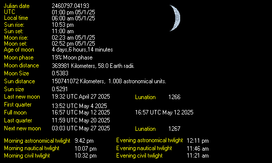
Weather Data
Weather Data
LAST READING AT TIME: 7:55 AM DATE: October 22 2024, time of next update: 8:00 am
Current WeatherStopped raining Current Temperature 36.9°F (2.7°C), Apparent temp 34.4°F
Maximum Temperature (since midnight)43.1°F at: 12:00 AM Minimum Temperature (since midnight)36.6°F at: 7:39 AM
Average windspeed (ten minute)2.2 mph Wind Direction (ten minute)S (171°)
Windchill Temperature 36.9°F Maximum Gust (last hour)9.0 mph at: 6:56 AM
Maximum Gust (since midnight)9.2 mph at: 6:56 AM Maximum 1 minute average (since midnight)6.6 mph at: 12:17 AM
Rainfall (last hour)0.01 in. (0.3 mm) Rainfall (since midnight)0.04 in. (1.0 mm) at 7:03 AM
Rainfall This month 0.40 in. (10.2 mm) Rainfall To date this year 6.56 in. (166.6 mm)
Maximum rain per minute (last hour)0.01 in/min Maximum rain per hour (last 6 hours)0.01 in/hour
Yesterdays rainfall 0.17 in DewPoint 35.1°F (Wet Bulb :36.2°F )
Humidity 93 %, Humidex 33.8°F Barometer corrected to msl30.345 in. (1027.6 hPa)
Pressure change +0.02 in. (last hour) Trend (last hour)RISING SLOWLY
Pressure change (last 12 hours)+0.22 in Pressure change (last 6 hours)+0.11 in

This page is updated from recent data collected by a DAVIS VANTAGE PRO weather station Use the Reload or Refresh facility on your browser to retrieve the latest data.


Click here for the last 24 hour graph
Click here for the last 48 hour graph
Click here for the last 72 hour graph
Click here for the month to date graph


Weather report/warning/Metars

Expires:202410222300;;708892
FPUS56 KOTX 221118
ZFPOTX

Zone Forecast Product for Eastern Washington and North Idaho
National Weather Service Spokane WA
417 AM PDT Tue Oct 22 2024


IDZ026-WAZ032-222300-
Lewiston Area-Lower Garfield and Asotin Counties-
Including the cities of Lewiston, Lapwai, Peck, Culdesac, 
Gifford, Clarkston, and Pomeroy
417 AM PDT Tue Oct 22 2024

.TODAY...Patchy fog in the morning. Sunny. Highs in the lower 50s
to lower 60s. 
.TONIGHT...Mostly clear. Lows in the mid to upper 30s. 
.WEDNESDAY...Cloudy. A chance of rain in the afternoon. Highs in
the mid 40s to mid 50s. Chance of precipitation 50 percent.
Rainfall amounts less than a tenth of an inch. 
.WEDNESDAY NIGHT...Partly cloudy with a 50 percent chance of
rain. Lows in the lower to mid 30s. 
.THURSDAY...Sunny. Highs in the upper 40s to upper 50s. 
.THURSDAY NIGHT AND FRIDAY...Partly cloudy. Lows in the lower to
mid 30s. Highs in the mid 50s to lower 60s. 
.FRIDAY NIGHT...Partly cloudy. Lows in the upper 30s to lower
40s. 
.SATURDAY...Warmer. Partly sunny with a 20 percent chance of
rain. Highs in the 60s. 
.SATURDAY NIGHT...Rain likely. Lows in the lower to mid 40s.
Chance of precipitation 60 percent. 
.SUNDAY...Rain likely. Highs in the mid 50s to lower 60s. Chance
of precipitation 70 percent. 
.SUNDAY NIGHT...Mostly cloudy with a 50 percent chance of rain.
Lows in the upper 30s to lower 40s. 
.MONDAY...Rain. Highs in the upper 40s to mid 50s. Chance of
precipitation 90 percent. 

$$


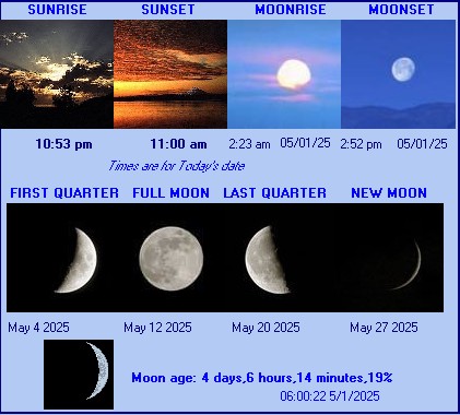
LEWISTON NEZ PERCE CO AIRPORT , ID, United States (KLWS) 46-22N 117-01W 438M
Oct 22, 2024 - 09:56 AM EDT / 2024.10.22 1356 UTC
Wind: Calm:0
Visibility: 1/4 mile(s):0
Sky conditions: obscured
Weather: fog
Temperature: 42.1 F (5.6 C)
Dew Point: 41.0 F (5.0 C)
Relative Humidity: 95%
Pressure (altimeter): 30.3 in. Hg (1026 hPa)
ob: KLWS 221356Z 00000KT 1/4SM FG VV002 06/05 A3030 RMK AO2 SLP266 T00560050 
cycle: 14


The data is logged at two minute intervals, but there is data recorded every minute.

Use the RELOAD facility on your browser to retrieve the latest data.

Click here for a daily update of the averages/extremes to date for the month
Created by "Weather Display" software version 10.37S149 at this start time/date 1:23:21 PM 10/10/2024